
Point clouds editing coming to @qgis.fosstodon.org.ap.brid.gy
22.01.2025 07:59
👍 8
🔁 3
💬 0
📌 0

@goodmapbadmap
The blurry line between art and science. Here for the open data, geospatial, product design, radical cartography, EO, cloud-native & open-source tech chatter, but I don’t mind motorbikes, cacti, geology, or anything Unreal engine either.
Point clouds editing coming to @qgis.fosstodon.org.ap.brid.gy

Hi Bluesky! We're welcoming in 2025 with a new Kart release. v0.16 includes significant speed improvements to vector & tabular data handling. Download from kartproject.org or read more at github.com/koordinates/...
My brain
Zero chance I'll be able to make it, but hope a lot of the talks are shared afterwards! Sounds like an amazing event.


#orienteering is certainly the best sport on earth for #map and #cartography lovers: It's outdoor, in the nature, you visit 'uncharted' areas of your neighborhood and apply multicriteria route optimisation algorithms. Maybe the sport you need for 2025 ?!
#gischat #sport #iof

Open Data ● Maxar's Open Data Program provides satellite imagery for major crises, offering pre- and post-event data to support humanitarian efforts. Imagery, released under Creative Commons BY-NC 4.0, helps organisations respond more effectively to natural disasters like floods, earthquakes, and wildfires. ● OpenStreetMap US presented the latest updates to the Public Domain Map (PDMap) project. It allows mappers across the United States to edit, contribute, and consume federal datasets via a collaborative user environment and modified versions of popular OpenStreetMap tools, thereby simultaneously improving government and OSM datasets.
Well it's not really #opendata then is it weeklyosm.eu/archives/17625
#geospatial #openwashing


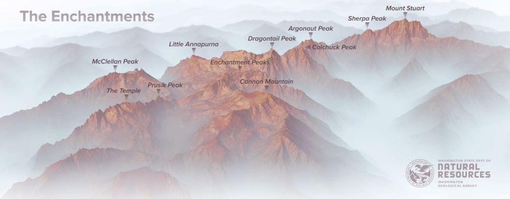
New #lidar images of the #Enchantments for the Washington Geological Survey. #PNW #Maps #CascadeRange
Working on our regional-scale point coud vis capabilities at Koordinates. Several hundred GBs of data previewed. Scaling up to TBs soon. And of course with clip & ship downloads, format and CRS shift, API access, version control built it. #gischat
Me too.... Do you think its far off?

Those styles were based partly on this set by @timlinux.bsky.social plugins.qgis.org/styles/149/ and this set by Warren Davison www.esri.com/about/newsro... which I imported to #QGIS using the #SLYR plugin by @north-road.com

#gischat

#30DayMapChallenge
Day 24: Only Circular Shapes
Fellsburg, Kansas
Damn.... 'Dog' made my eyes sweat alittle.

Artist Olivia de Recat has created minimalist illustrations using two lines to depict the evolution of various relationships over time.
Olivia has published a book titled "Drawn Together: Illustrated True Love Stories”
#dataviz #datastories #relationships
😶🌫️
Great tool. Thanks for building it. We will use it to compare different styles of basemaps.linz.govt.nz vector tiles.

Hello hello whats this then 😁

Just released a new version of our QGIS Kart Plugin - now with Processing extensions so you can start building workflows on top of your versioned Kart repositories. plugins.qgis.org/plugins/kart/
#30DayMapChallenge
Day 17: Collaboration
High Resolution Canopy Height Maps: a *collaboration* btw Meta & World Resources Institute showing canopy height at 1m resolution.
Methods for display using vector/terrain tiles:
darrens-geospatial-curiosities.netlify.app/canopy-height
#gischat #geosky

