

A cold front will cross on Thursday and provide scattered showers and storms. The strongest storms could produce gusty winds and small hail. The best chance to see these storms will be during the afternoon. We will dry out once again Thursday night. #wvwx
03.09.2025 15:14
👍 0
🔁 0
💬 0
📌 0

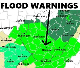
Air Quality Alert for the ENTIRE state of WV until 10 PM tonight. Elevated particulate matter levels from Canadian wildfire smoke could be unhealthy for sensitive groups. #wvwx
05.06.2025 17:53
👍 0
🔁 0
💬 0
📌 0


Our heat and humidity are increasing as high pressure shifts to our east. This will allow a slow-moving cold front to inch a little closer this afternoon. Though we will stay dry today, our risk for storms begins to increase tomorrow afternoon. #wvwx
04.06.2025 14:12
👍 0
🔁 0
💬 0
📌 0

The weather pattern is in the midst of turning much warmer for our region! Though we have thunderstorms across the mid-section of the country today, it will still be about three days before they arrive in our region because of a strong high pressure system nearby. #wvwx
03.06.2025 17:10
👍 0
🔁 0
💬 0
📌 0

AURORA VIEWING IN WV: Head outside tonight! The University Alaska-Fairbanks is forecasting some viewing opportunities tonight in the Mountain State. With mostly clear skies, the only deterrent could be some of the smoke from the Canadian wildfires in our atmosphere. #wvwx
01.06.2025 13:24
👍 1
🔁 0
💬 0
📌 0


Smoke from numerous Canadian wildfires will be impacting our weather: 1) You may notice a slight haze to the sky, particularly Saturday PM. 2) Smoke commonly will keep temperatures a little cooler than models indicate, as they do not take smoke into consideration. #wvwx
31.05.2025 14:29
👍 0
🔁 0
💬 0
📌 0

Tornado Watch until 8 PM for McDowell and Wyoming counties in southern WV #wvwx
20.05.2025 17:47
👍 0
🔁 0
💬 0
📌 0

SEVERE THUNDERSTORM WATCH until 6 PM for much of southern West Virginia. A complex of showers and thunderstorms, which are expected to be strong to severe will move into the region this afternoon. Damaging wind gusts are the primary threat. #wvwx
16.05.2025 15:14
👍 0
🔁 0
💬 0
📌 0

Friday afternoon, our atmosphere will get 'juiced' up with heat & humidity. This will support a complex of strong to severe storms, which will push through between 5 PM and 10 PM Friday. Damaging wind gusts are the main threat, but an isolated tornado cannot be ruled out. #wvwx
15.05.2025 16:31
👍 0
🔁 0
💬 0
📌 0

Most of the day Thursday will be pretty quiet with a good bit of sunshine. However, a warm front will provide lift for stormsto feed off of. Storms to our west Thurs. evening in KY will "follow" the warm front, providing storms. A couple of those storms could be strong. #wvwx
14.05.2025 22:45
👍 0
🔁 0
💬 0
📌 0

Watching thunderstorms trying to build as they develop/move east from southern Kentucky into southwestern Virginia. Decent environment will remain in place for damaging wind/hail threat over the next few hours. #wvwx #vawx
08.05.2025 21:18
👍 0
🔁 0
💬 0
📌 0

COUPLE STRONG STORMS THURSDAY: A boundary scooting through during the late afternoon Thursday will provide the risk for a couple of strong to severe thunderstorms in southern WV through the early evening. These storms will be capable of damaging wind gusts and small hail #wvwx
07.05.2025 17:31
👍 0
🔁 0
💬 0
📌 0


My mom sent this picture of the hail just east of Charleston - pretty big stones! Lookout in the Sissonville area in the next twenty minutes. #wvwx
05.05.2025 18:06
👍 0
🔁 0
💬 0
📌 0

Likely a hail maker moving into Charleston #wvwx
05.05.2025 17:46
👍 0
🔁 0
💬 0
📌 0


We are seeing downpours popping up with the sun’s heating - though our severe weather threat is low, cold air in the mid-levels will provide the chance for small hail in storms that grow decently vertically this afternoon - the best chance for this is west of the turnpike. #wvwx
05.05.2025 16:17
👍 0
🔁 0
💬 0
📌 0

Stout thunderstorm with likely strong winds and small hail entering Upshur County. Big storm headed for Buckhannon area shortly. #wvwx
04.05.2025 22:51
👍 0
🔁 0
💬 0
📌 0

Storms are organizing into line segments that are moving due north this afternoon. An isolated threat for damaging wind gusts, small hail and perhaps a tornado will continue for a couple more hours across central WV. #wvwx
04.05.2025 20:15
👍 0
🔁 0
💬 0
📌 0

Big time wind showing up in the northern panhandle near Steubenville #wvwx
29.04.2025 20:47
👍 0
🔁 0
💬 0
📌 0

Heck of a bow echo cutting through eastern Ohio and heading toward the northern panhandle on the I-70 corridor. #wvwx
29.04.2025 20:29
👍 0
🔁 0
💬 0
📌 0


Good weekend trend! A northern jaunt for our incoming low pressure will allow for several hours of dry time to develop between R1 Sat. PM and R2 Sunday AM. STILL looking at 1 to 2 inches of rain. Still some flooding issues expected with combined mountain snowmelt. #wvwx
14.02.2025 16:18
👍 0
🔁 0
💬 0
📌 0


I cannot emphasize this enough - if you live in a flood-prone area in WV, remain aware this weekend. A warm front, with training downpours followed by a cold front will result in 2-3 inches of NEW rain on top of melting snowpack & could cause significant flooding. #wvwx
13.02.2025 17:08
👍 0
🔁 0
💬 0
📌 0


The heaviest rain is exiting WV now. 1-1.5" of rain has fallen across much of central and southern WV - enough to see low-lying flooding spots develop, especially in combination with snowmelt. An additional 1/4-1/2" of new rainfall can be expected this afternoon with our front crossing. #wvwx
31.01.2025 14:39
👍 0
🔁 0
💬 0
📌 0


We are dry until Thursday, when a low pressure system arrives during the mid-afternoon into Friday. With a general 1-1.5" of rain expected in combination with snowmelt, an isolated high water spot or two cannot be ruled out. However, this threat overall is very low. #wvwx
29.01.2025 02:38
👍 1
🔁 0
💬 0
📌 0
That will be awesome!
29.01.2025 02:38
👍 1
🔁 0
💬 0
📌 0


On this day in January 1937, historic flooding was occurring on the Ohio River, resulting in 350 deaths. The Ohio River crested 19.5 feet ABOVE flood stage in Huntington and 22.7 feet ABOVE flood stage in Point Pleasant. Photos provided by the US Corps of Engineers. #wvwx
29.01.2025 00:00
👍 0
🔁 0
💬 0
📌 0
Warmer than last night!
23.01.2025 05:30
👍 1
🔁 0
💬 0
📌 0

SNOW ON SATELLITE: A photo like this will likely not be viewable often in our lifetimes - check out the snow in the south! Whether it's in LA, southern AL, GA, SC, NC or western FL, the snow on the ground is visible from space! You can see the snow on the ground in WV, too! #wvwx
22.01.2025 20:54
👍 0
🔁 0
💬 0
📌 0

Temps are dropping QUICKLY now that our last punch of polar air is pushing into the Mountain State. We're still expecting temperatures to drop below zero throughout the state as we head toward dawn. Tonight is still shaping up to be the coldest night for most since 2022! #wvwx
22.01.2025 08:03
👍 0
🔁 0
💬 0
📌 0
Despite temps in the 40s and low 50s today, any instability in combo with wind energy present could allow for a storm or two to be severe around lunchtime into the early PM, with damaging wind gusts the primary threat. An isolated tornado also cannot be ruled out.
31.12.2024 14:44
👍 0
🔁 0
💬 0
📌 0


