Or indeed their root vegetables.
21.01.2026 22:49
👍 2
🔁 0
💬 1
📌 0

@docuracy.co.uk
Technical Director & Lead Software Developer, World Historical Gazetteer @whgazetteer.org Research Associate, Unlocking Upcycled Medieval Data @ihr.bsky.social GIS Consultant, Layers of London @layersoflondon.bsky.social
Or indeed their root vegetables.
Talking of books, you might like the section on Agriculture in the Shropshire @vch-home.bsky.social, which discusses the turnip prizes awarded to Lord Clive's tenants.
www.british-history.ac.uk/vch/salop/vo....

Are these like the "Grey Wethers" in Lockeridge Dene? www.megalithic.co.uk/article.php?...
Astonishing. The development of ship design and capacity is something our analysis of London's medieval customs accounts may illuminate. @justincolson.bsky.social @ebenbow.bsky.social @histgrove.bsky.social

Fun piece by @justincolson.bsky.social and Werner Scheltjens.
My job on this project is to turn messy medieval records into a tidy database so that my colleagues can more easily spot trends in fashion, industry, and commercial networks.
theconversation.com/medieval-lon...
Interesting, thanks for posting. But a quick check of buildings in my neighbourhood indicates massive underestimation of their heights, so I hope that the broad analysis of economic development that it purports to offer is not relied upon in any policy-making circles. Classic AI trap.

(4) Linking Knowledge Through Place: ISHI, WHG, and the Future of Gazetteer Collaboration, with @rmostern.bsky.social @docuracy.co.uk, Alexandra Loranna, Palak Vashist. Look at Institute for Spatial History Innovation & World Historical Gazetteer. Register to participate at forms.gle/dzSq2GibT17n...
Linked Pasts 11 programme (December 1–5 and some 8–12)
linkedpasts.hcommons.org/2025/11/09/l...
The website hasn't quite caught up yet: just awaiting approvals before we jump straight to publishing a 3.2 release, complete with a Reconciliation API, hopefully in the coming week.
Thank _you_ for entrusting this exceptionally challenging and rewarding project to me, @kgeographer.bsky.social !

Death cap and false death cap, red and orange fly agaric, lawyer's wig, penny bun and blusher.
This week's fungi for #FungiFriday.
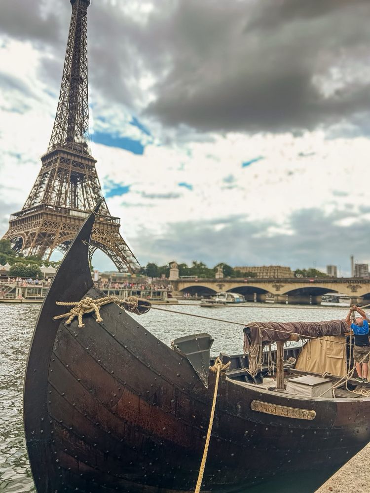
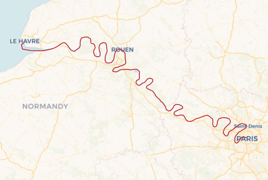
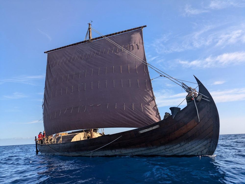
Today I start my research trip sailing down the River Seine from Paris to Honfleur (via a few stops) in a reconstruction of the Klåstad cargo ship built in 998. It’s the penultimate stage in the ship’s journey from Rome to London throughout the summer. I’ll post updates as we go #Saga25 #MedievalSky
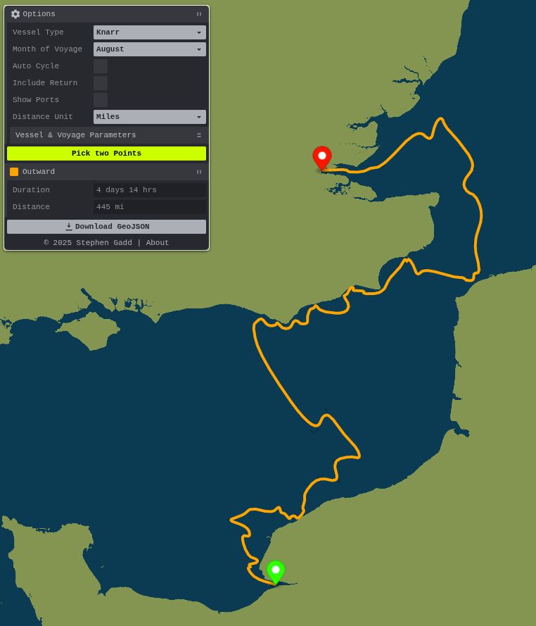
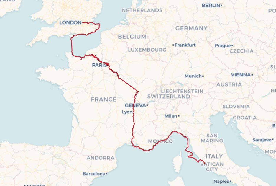
Predicted optimum route from Honfleur to London for a knarr sailing in August.
Sounds amazing!
I'm curious to see how closely the cross-Channel route and timing match this 4-or-5-day wind-and-current-based prediction from docuracy.github.io/Historical_S...
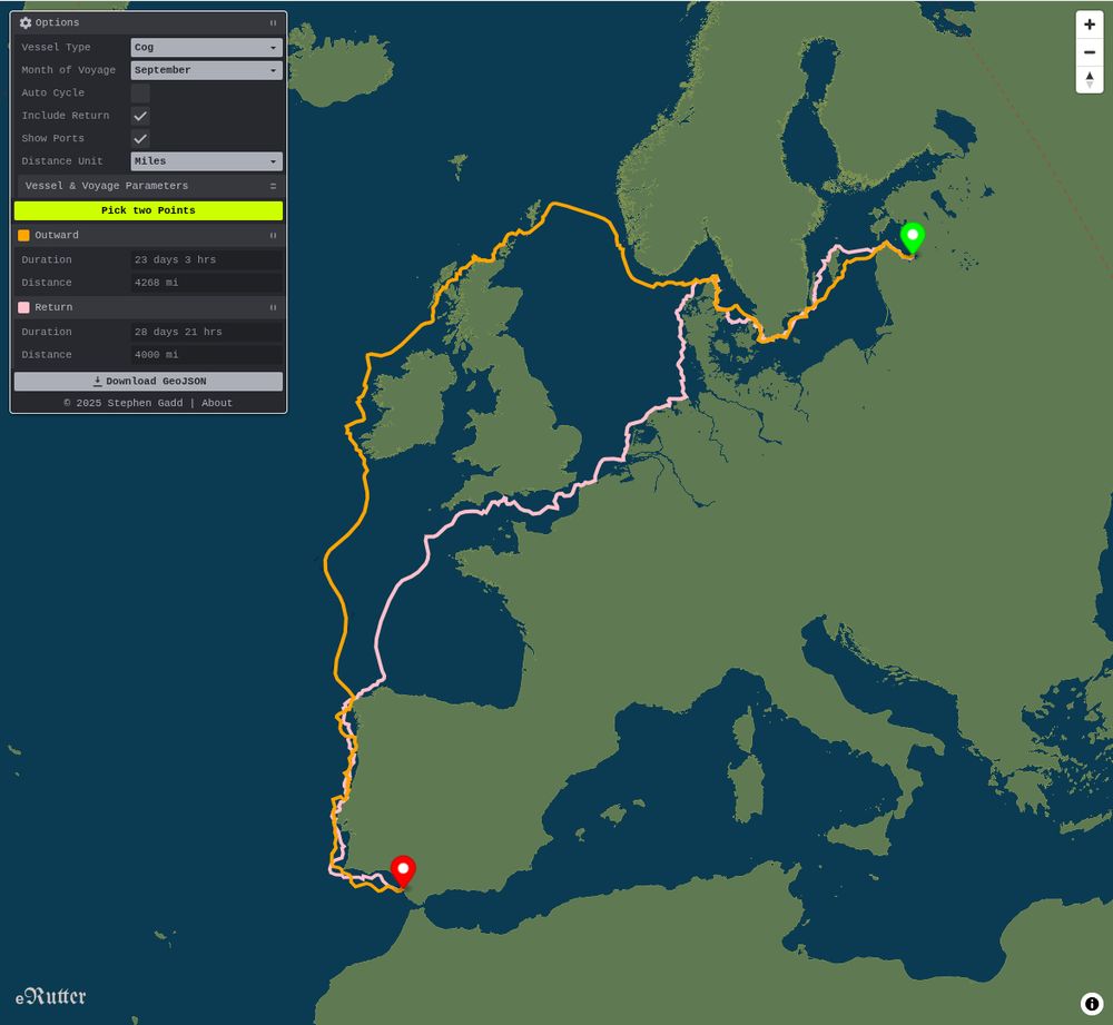
Map of northern and western Europe showing computed square-rigged sailing routes between the Baltic Sea and Spain. Outward journeys curve northwest via Shetland and the North Atlantic, while return journeys favour the English Channel. This asymmetry arises from prevailing winds, currents, and the hydrodynamic limits of medieval sailing vessels. A spherical (non-Mercator) projection is used, better reflecting great-circle geometry and the true spatial relationship of regions such as Scandinavia, Shetland, and Iberia.
Hours of fun spent realigning my foolishly London-centric assumptions about medieval European trading networks. Shetland, for example, was far from peripheral: a non-Mercator map-projection helps.
I've rebuilt the journey-timed, square-rigged sailing algorithm for docuracy.github.io/Historical_S...

Data table showing labor market outcomes for select college majors including Computer Science, Engineering, Graphic Design, English, History, and Philosophy, detailing their unemployment and underemployment rates, early and mid-career median wages, and the financial impact of unemployment and underemployment on mid-career earnings.
That's not what I see. Apply those unemployment rates to mid-career wages and it's evident that humanities are not a "safe financial bet". The situation is even worse when you factor in underemployment and investment in graduate degrees.
Thanks, @drpda.bsky.social, this looks like a really useful source, as it includes dates and waypoints for a number of long-distance voyages. 👏
I'd love to get hold of Paula Martin's transcript, though: any suggestions of how I might do that?
🌍 Ports are now (optionally) shown on the eRutter to help with route picking.
🤔 They're currently fetched from @wikidatacommunity.bsky.social, but this would be a great use case for a @whgazetteer.org temporal API to filter out modern ports and highlight ancient ones.

The grid of H3 cells at blended resolutions strikes a balance between detail and responsiveness.

A grid of H3 cells over land facilitates computation of the visibility of features out at sea.
... 📖 All of the code for extending coverage can be found together with an outline of the methodology at github.com/docuracy/His.... [3/3]
Screenshot showing mobile optimisations: Mercator map projection, and initially-closed Options panel.
... 📱It works better on mobile devices now too, using Mercator projection instead of globe, and with an initially-minimised Options panel. The routes and all parameters used can be exported for use in other GIS applications. [2/3]
🪄Historical Sea Routing is now much quicker to load, reload, and compute seasonally-plausible sailing routes, thanks to some behind-the-scenes browser magic. Find a 6500-mile return trip in under 1 second!
🛟 Do you have historical voyage data which might help with calibration? [1/3]
🌍 I've just published this here docuracy.github.io/Historical_S... for anyone to play with.
Screenshots, code, and caveats at github.com/docuracy/His....
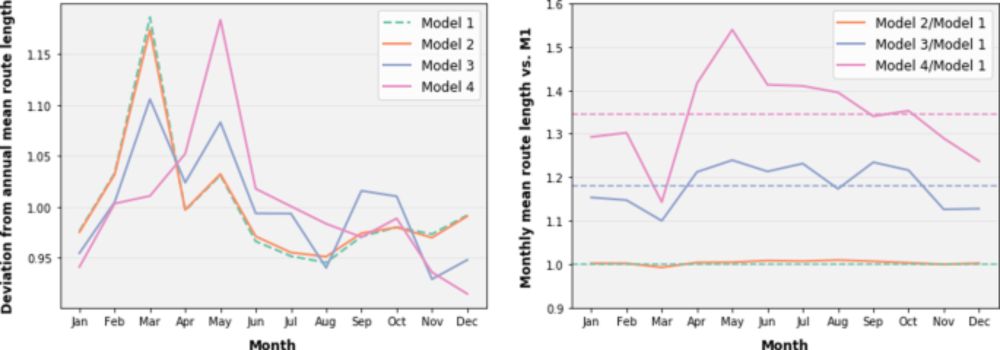
... Time of year makes a big difference too.
Monthly-weighted graphs are switched and new routes computed in less than half a second, all within the browser.

In September, the least-cost path from the west of Ireland to the east of England tracks around the north of Scotland. This indirect path reflects prevailing winds, currents, and swell patterns that favour northerly routing during this month, despite the longer distance.

... whereas the least-cost path from the east of England to the west of Ireland tracks through the English Channel. This asymmetry highlights how environmental factors such as wind direction, wave conditions, and current flow make the return journey optimally follow a very different path.
... I need yet to tune the weighting of various parameters, but it’s striking how the same principles that shaped trans-Atlantic triangular trade routes in the age of sail apply on a more local scale too: prevailing winds, swell, waves, and currents all make return routes diverge from outbound ones.
... Inspiration:
doi.org/10.1057/s415...
doi.org/10.1515/9783...
Data sources: @copernicusecmwf.bsky.social, @copernicusmarine.bsky.social

Chart of route-graph cells indicating clear-weather land-visibility and sea-depth<15m
... 🌊Each cell now has bathymetry and DEM-based clear-weather land-visibility data; also month-wise indicators of hourly-average wind, waves, surface current, and nocturnal+meteorological attenuation of visibility.
Thanks to @viabundus.bsky.social and @alexislitvine.bsky.social for inspiration!

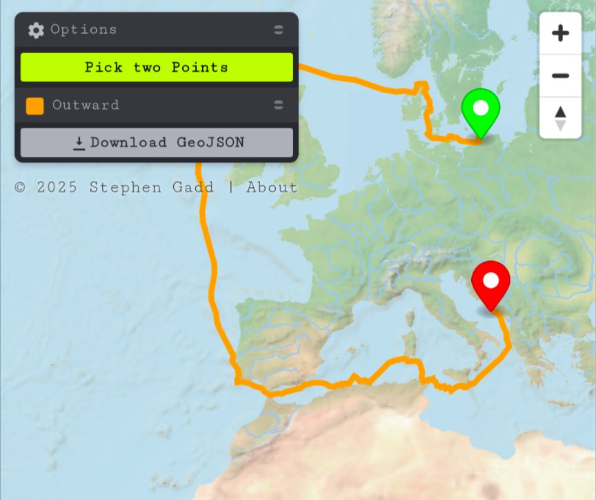
Map showing speculative computed historical sea route, favouring coastal sailing.
... using this graph of interconnected H3 (Hexagonal Hierarchical Geospatial Index) cells, I've computed and plotted a speculative historical sea route from Kilcolgan Castle to Faxfleet in under 2 seconds, all running in the browser. No server infrastructure or internet connection needed! ⛵
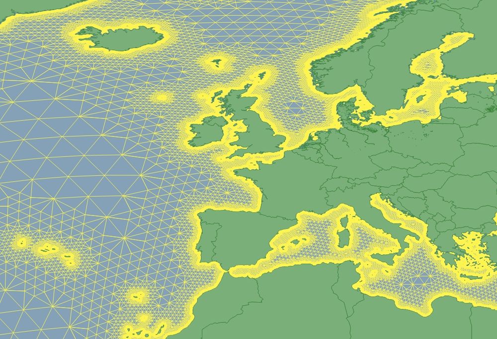
Diagram of historical sea routing graph for Europe.

Diagram of historical sea routing graph for Europe, showing (in red) weighted edges in the zone favoured for coastal sailing (~5km).
🧭 Building a lightweight sea-routing graph for historical GIS & DH use cases beyond simple port-to-port hops. Edges are weighted for ~5km coastal preference. Aiming for serverless exploration of connectivity in historical maritime trade. ⚓️ #MaritimeHistory #HistoricalGIS #DigitalHumanities
Want to work with the WHG team? The Institute for Spatial History Innovation @ Pitt is hiring a full-time Research Associate to be the Digital Data Specialist & Managing Editor of World Historical Gazetteer!
Learn more & apply by July 11: bit.ly/4kAknki
@rmostern.bsky.social @docuracy.co.uk
My understanding is that in respect of markets and fairs such charters granted rights rather than obligations. Historical legal sources (e.g. Chitty, 1820) focus on forfeiture for misuse rather than non-use: there was not legal compulsion to operate what became unprofitable or impractical.

Medieval England’s Road Network Mapped Using the Gough Map.
www.medievalists.net/2025/05/medi...

